These days, instruments like sextants and measuring rods aren’t necessary for “measuring the globe.” When it comes to measuring global phenomena like sea levels, massive ice sheets, or the water cycle, geodesy is increasingly dependent on satellites. But what are the mechanics and techniques of surveying the Earth from space?
Due to its many benefits, satellite geodesy has become an integral part of modern Earth systems and climate studies. Taking a look at Earth from orbit using a geodetic instrument provides a comprehensive overview of our planet and its interconnected systems. However, the satellites can still take quantitative readings of a number of different factors. Both satellite gravimetry (the measurement of gravity from space) and satellite altimetry (the use of radar to examine the topography of water, ice, or land) are widely used nowadays.
History of measuring the Earth
From triangulation to satellite
Carl Friedrich Gauss and Alexander von Humboldt were two of the most famous geodesists. Common knowledge recognizes the two gentlemen for their work in mathematics and the natural sciences, respectively. The central goal of geodesy is the process of measuring and charting the Earth’s surface. As a matter of fact, Gauss and von Humboldt accomplished just that in the 18th century.
Gauss is famous for his involvement in surveying. His work in practical measurement informed many of his mathematical innovations, including the least squares estimate approach and his statistics. The latter is represented by Gauss’s normal distribution. On all of his explorations, Alexander von Humboldt carried surveying instruments, proving that he was also a dedicated geodesist.
The dream of surveying the Earth
One of the ultimate goals of geodesy is to take a global measurement of the Earth. The groundwork for this was created 150 years ago, in 1862, when Prussian General Johann Jacob Baeyer called delegates from Prussia, Austria, and Saxony to Berlin to examine his plan for a Central European linear measurement. The International Association of Geodesy (IAG) was officially founded when more European nations joined the proposal.
But it wasn’t until the era of satellites that the hope of conducting a truly worldwide survey of Earth came to fruition. Only from space is it possible to conduct a global survey with consistent precision and in a reasonable amount of time. Earlier and more accurately than any previous terrestrial measurements, the flattening of the Earth was able to be calculated from observations made during the first Sputnik orbit. After that point, satellite geodesy progressed quickly. Think of the potential social and economic benefits of global satellite-based navigation systems like the United States’ Global Positioning System (GPS) and Europe’s Galileo.
The principle of satellite altimetry
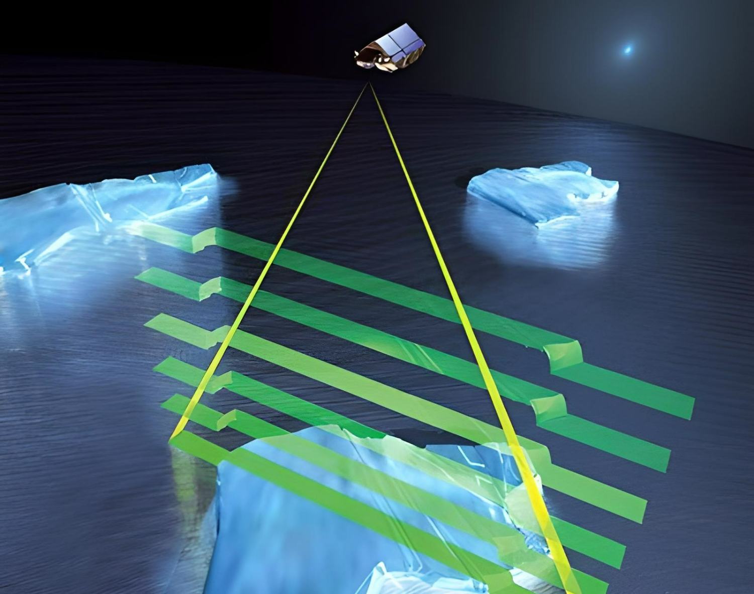
Satellite altimetry monitors geometry, including depressions and elevations of the terrain, water, or ice, while satellite gravimetry records the distribution of big masses on Earth. The basic premise of the measurement is straightforward: a satellite emits a radar pulse to the ground, which is then reflected by an object like the ocean’s surface and sent back to the satellite. With accurate knowledge of the satellite’s orbit and, more importantly, its altitude (as provided by GPS data, for instance), the height of the ocean’s surface can be calculated from the duration of the radar waves’ journey. In this technique, the ground track right below the satellite’s orbit is scanned, providing a profile of the Earth’s surface.
Tides, El Nino and other fluctuations
Four decades have passed since the first use of satellite altimetry. American and French scientists worked together to create a new generation of altimeter flights. Such measurements are often taken by satellites operated by NASA and the European Space Agency (ESA). In 2016, the European Union deployed Sentinel-3, the successor to the unsuccessful Envisat satellite, into orbit as part of the GMES Earth surveillance program.
The primary purpose of satellite altimetry is ocean monitoring. Because of this, oceanography has made enormous strides forward, allowing for more precise tidal models, continuous monitoring of global ocean circulation and its variations, the recording of smaller-scale structures like eddies and tsunamis, and a deeper understanding of the El Nio phenomena.
The rise in sea levels
However, sea level is also a crucial factor in studying climate. Long-term, precise, and spatially consistent monitoring of ocean surfaces is now possible because of satellite altimetry. This is the only method to accurately predict the increase, and it plays a vital role in many studies, including those of the Intergovernmental Panel on Climate Change (IPCC). Because of altimeter readings, it is feasible to pinpoint areas experiencing increasing and declining sea levels, for instance.
There are so-called interannual influences, such as the El Nio phenomenon, that may produce localized sea level fluctuations over the course of many years. Despite some variances, a coherent picture emerges from the data collected by the numerous altimetry satellites.
How satellite altimetry can also help in hydrology
However, it is only via the integration of gravimetric and geometric techniques that satellite geodesy begins to show any signs of genuine promise. By correlating changes in an ice sheet or river mass as measured by the gravity field with changes in sea level as recorded by altimeters, researchers can isolate the contributions of ice melt and thermal expansion to sea level rise, among other factors. Such independent measurements are crucial for supporting the viewpoints in the IPCC reports since the values can be calculated without the use of modeling or climatic assumptions.
Surveying the Earth for climate research
The ongoing discussion about climate change highlights the necessity for constant Earth monitoring. Sea levels are increasing, as is often reported in the news. When compared to the size of waves and tides, which may be many orders of magnitude greater, measuring changes of just approximately three millimeters (0.11 inches) each year can be a challenge. And where does the water come from?
The average amount of water expands as its temperature increases; this phenomenon helps to explain the rise in sea levels. However, the most compelling explanation for sea level rise is a massive redistribution of water and ice in the Earth’s hydrological cycle.
Researchers at the Potsdam Institute for Climate Impact Research (PIK) first used the phrase “tipping points” to describe a critical turning point in the climate change debate. These metrics are crucial for understanding the state of the global climate. For some years now, geodetic satellites have seen the rapid retreat of the Greenland Ice Sheet. At around half of the “tipping points”, satellite geodesy performs an essential observing role. The critical parameters are determined with the aid of two distinct geodetic satellite systems.
Let’s take a look:
How does satellite gravimetry work?
The gravitational field is a dead giveaway
How can we “weigh” the changes in mass on Earth on a global scale from outer space, like Greenland’s melting? The key to this is taking an indirect route. As mass is redistributed on a global scale, the Earth’s gravitational field shifts. The Earth’s gravitational field is “just” a representation of the distribution of all masses inside and on the planet. These changes in time can be measured, even to the sixth or seventh digit.
Dissimilarity as a clue
Like an astronaut on the International Space Station, a satellite seems to float in space, unattracted to the planet Earth. But the force of gravity does, nevertheless, operate upon them; and the orbital motion counteracts this effect. Although the strength of this pull cannot be determined directly, it can be inferred from the relative positions of two satellites. Due to their relative locations in Earth’s gravitational field, they experience various levels of attraction. And due to their free-falling nature, the distances between satellites vary.
The GRACE satellite project (2002–2017), a joint effort between the United States and Germany, put this concept, known as “low-low satellite-to-satellite tracking,” into practice. Two identical satellites have been orbiting the Earth at around 280 miles (450 kilometers) in the polar region for the last decade. Both satellites were in geosynchronous orbit, but one was roughly 125 miles (200 kilometers) ahead of the other, so they pursued each other at nearly 30-second intervals. K-band ranging can measure distance changes between satellites to within around 32 ft (10 m). Geodesists created a gravity field map of Earth almost monthly using these precise observations.
Changes over time are important for climate research
However, such findings are only relevant to climate science when the monthly gravity fields are arranged sequentially, as in a film. The end result was a 10-year time series of gravity field shifts, or mass changes in the Earth’s system. However, satellite gravimetry can only discern such changes on spatial scales bigger than around 250 miles (400 kilometers) owing to the height of the satellites and the relatively low sensitivity, notwithstanding the accuracy of the readings.
While hydrologists, ice scientists, and geophysicists had never observed the Earth in this way previously, the time series of mass changes gave them a more complete picture. But if you’re interested in learning more about our planet but want to go beyond the traditional methods of satellite remote sensing, satellite gravimetry will give you a whole new perspective. In this method, gravitational interaction is used instead of electromagnetic waves.
Observing Earth’s water masses from space
How satellite measurements provide information about water distribution
The equivalent water height is a common way of expressing mass displacements on the Earth, since many of these movements are tied to the water cycle. It represents the deviation from a reference height of the gravitational field caused by the presence of water masses. But not every satellite’s gravitational signal can tell the difference between water on the surface of the Earth, water in the soil, water in the ground, or water in the biosphere. Thus, vertical separation is not possible. However, this has the benefit of providing a standardized measurement and international perspective.
Gravity field reflects water and ice distribution
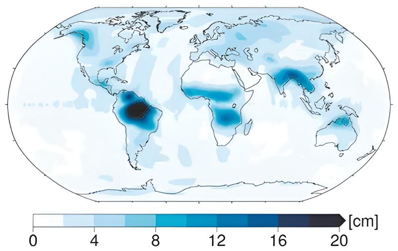
Global variations in comparable water height are seen on this map. While other timescales have a role, it is the yearly cycle that is of most interest here. Each color on this map represents the amplitude of a yearly sine wave, which can be determined by looking at the associated pixel.
The water level in the Amazon basin reservoir, for instance, fluctuates yearly by as much as 8 inches (20 cm). It’s also clear that the Amazon and the Orinoco Basin are geographically distinct from one another. Other places with significant hydrologic activity include the confluence of the Ganges and the Brahmaputra rivers, as well as the tropical regions of Africa and northern Australia.
Bright colors can draw attention to the more hydrologically inactive continental regions, such as deserts and Antarctica. Current satellite gravimetry’s limits are also shown on the map. The spatial resolution is inadequate for several regions, including the islands of Indonesia.
It’s commonly known that the desert experiences relatively little in the way of hydrological activity, whereas the tropics are home to a flurry of activity. The novelty of satellite gravimetry is that it allows metrological and worldwide quantification of mass turnover with consistent precision and homogenous, although coarse, spatial resolution.
Because of the long-term fall in the number of terrestrial hydrological and meteorological monitoring stations, this is of critical importance. Maintaining infrastructure like river gauge stations over extended periods of time is today an expensive endeavor for many nations.
Thawing glaciers and trembling earth
Use of gravity field measurements for climate research and more
Long-term shifts in the global distribution of water and ice can also be gleaned from satellite measurements of the Earth’s gravitational field. They reveal locations where the Earth’s crust seems to be rising, such as in Scandinavia and North America. This is because, after the previous ice age, the land masses rose due to postglacial uplift. The Earth’s crust was pushed inward by the then-existing, one-kilometer-thick (0.60 mile) ice sheets; since their melting, the crust has been slowly springing back out again, at rates of up to one centimeter (0.40 inch) per year, which can be detected using other geodetic measurement techniques like GPS or from geological analyses.
Melting hotspots
The data for Greenland and West Antarctica are the most worrisome. They prove that something more than a simple rebound of the Earth’s crust is happening there, namely, changes in the gravitational field. The Greenland ice sheet is losing around 300 gigatons of ice every year, more than it gains from snowfall, and this is the reason.
Its mass is equivalent to that of a cube of water having a length of one kilometer on each of its sides, or one gigaton. The average annual increase in sea level caused by the melting of 300 such ice cubes is around 0.85 millimeters (0.03 inches). As a whole, this may not seem like much. Still, Greenland is responsible for approximately a centimeter (0.04 inches) of the ocean’s overall average increase in only a few years. There has been a recent speedup in the melting process in recent years.
Ice masses also have an attraction
This method of measuring sea level rise can only ever provide an average figure for the whole ocean. However, in actuality, the meltwater is not uniformly dispersed over the world’s seas. Massive masses like Greenland’s ice sheet have their own gravitational influence, raising sea levels locally. When Greenland’s ice sheets melt, their gravitational pull weakens, and the seawater in the area is attracted to them to a lower degree. As a consequence, local sea levels may fall even further. Since this is the case, melting Greenland need not negatively impact other continents, at least not in terms of sea level rise.
Antarctica is experiencing a significant ice loss, most notably in West Antarctica. The average annual increase in sea level is 0.5 mm (0.02 inches), which is about equivalent to the size of the problem (approximately 180 Gt/year). Nonetheless, studies of the gravitational field show that inland glaciers like those in Alaska and Patagonia are also shrinking. As a matter of scale, this may not be as important as Greenland or West Antarctica. However, melting is unmistakable evidence of global warming.
Rivers, groundwater, and earthquakes leave traces of gravity
Satellite gravimetry can detect even minute variations in water distribution, such as the volume of water in river basins. As seen by these measurements, the Amazon and the Zambezi both seem to be growing heavier or wetter. However, the findings suggest groundwater exploitation for agricultural reasons in California, the Middle East, and northern India. The gravity decreases when the water evaporates after being pushed out.
For instance, the shift in the Earth’s gravitational field due to the massive earthquake that struck Sumatra and the Andaman Islands in 2004 was quite intriguing. It was a sudden shift in the gravitational pull. This jump was reflected on the map because of the magnitude of the mass shift. It demonstrated that satellite-based gravity field changes are of interest to geophysicists in addition to hydrologists and ice scientists.


