Almost 20% of the Earth’s landmass falls under permafrost. In other words, 22.8 million square kilometers or 9 million square miles of land on Earth are always frozen. Over thousands of years, the soils have been beaten by the cycle of freezing and thawing, giving rise to unusual landscapes with unique and often spectacular forms and processes. Despite their shadowy existence, permafrost soils are very important to our planet’s climate and, by extension, to our own survival. They are useful for reconstructing more than just historical climatic stages. Climate change has a direct impact on the delicate ecology we have today, making global tendencies palpable.
However, there seems to be a lack of coverage about permafrost. This is likely because the permafrost is often located in cold, desolate regions of Siberia and North America populated by few people.
Permafrost facts at a glance
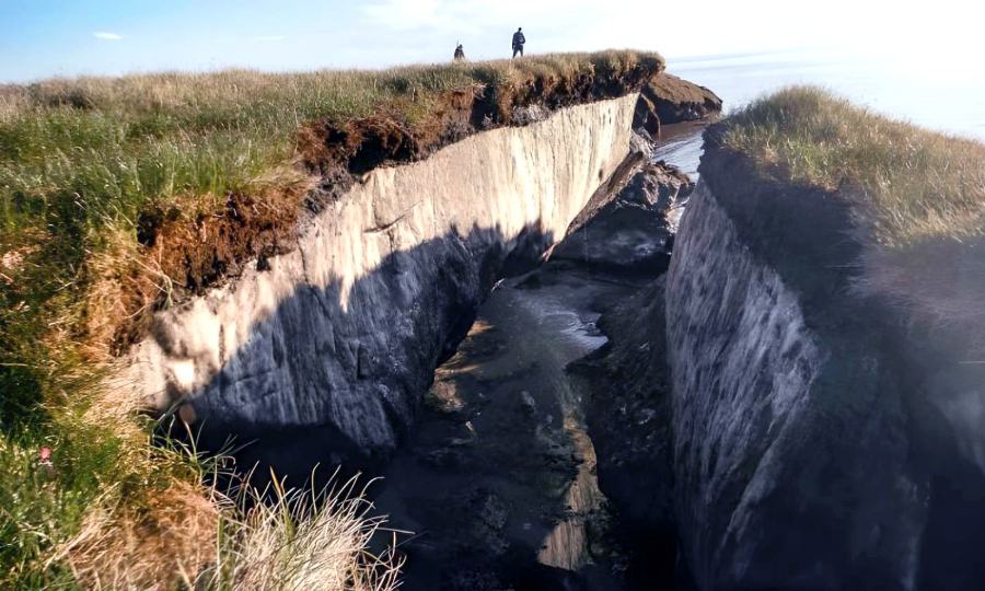
- When soil stays at or below 0 degrees Celsius for more than two years, it is considered permafrost. Consequentially, temperature plays a pivotal role in the definition; ice is incidental. The depth of permafrost may be up to 1,500 meters.
- Permafrost may be either widespread or quite localized, depending on the weather and geography. Permafrost soils are sometimes remnant forms of the ice era that would no longer exist today in areas where they do not cover practically the whole region. They barely survive in the current climate, slightly below zero, and are hence very sensitive to temperature changes.
- Approximately 9 million square miles (22.8 million sq km), or about the size of North America, is still covered by permafrost. Comparatively, just 3% of Earth’s surface is permanently covered with ice and snow. The periglacial highlands and locations near to the poles are where permafrost is most prevalent.
- Numerous distinctive surface features are shaped by processes occurring in the periglacial zone. The thawed layer of permafrost, for instance, slides very readily down inclines because of the water it contains. As a result of this soil movement, whole hills might be flattened. Repeated cycles of thawing and freezing put stress on the ground. As a result, the sediments and stones in the soil get thoroughly combined, creating characteristic frost-textured soils.
- Ecological stability is being threatened in permafrost regions as the delicate ecosystem there warms and thaws repeatedly. Oil seeping from broken pipes has contaminated the ground. Pressure and heat from buildings and roads melt the permafrost. Landscaping takes a long time, if at all, to recover after harsh weather.
- There are climatic records stored in the soils of permafrost. The soil temperature profile is especially reflective of long-term temperature variations. Long-ago climatic phases may be recreated by cooperation with other climate archives.
- Due to the increasing temperatures throughout the world, permafrost soils are thawing. A hundred kilometers of Canada’s permafrost barrier have thawed away already. Issues like soil subsidence and habitat loss are compounded by the release of greenhouse gases like carbon dioxide and methane that are normally stored in the soil. The pace at which the planet is warming will increase because of this.
- Large quantities of detritus in the high mountains are made mobile by the melting of permafrost soils. There has been and will be further landslides and debris flows. One-third of all debris flows in the Alps may be attributed to thawing permafrost. This is a growing threat to human life, particularly as people continue to settle in formerly uninhabited places that are now considered to be potential risk zones.
What is permafrost?
Getting close to an ephemeral phenomenon
The presence of ice and snow are not necessary conditions for a permanently frozen ground. It might have as much as 30% ice and be completely coated in snow, or it could have neither. Soil that stays below freezing for at least two years is considered to be permafrost. For this reason, temperature plays a pivotal role in the definition, with ice serving only as a corollary.
For permafrost to persist, it need colder than usual air temperatures. The soil type and intensity of sunlight are important factors. When exposed to sunshine, dark soil warms up more quickly than light soil does; coarse pebbles in the soil carry cold better into the soil and give increased pore space for water to freeze into ice, further cooling the soil. The soil temperature is also significantly impacted by vegetation and snow cover. Peat moss acts as insulation in the warmer months and as a cooling agent in the colder months. Intense soil cooling may be mitigated by deep snow cover. Soil frost is more likely to occur if snowfall starts late and a small snowpack lasts deep into the summer. This results in a landscape where permafrost soils vary greatly from place to place.
Soils in permafrost regions are not solid slabs of ice that extend from the ground up. In reality, they are made up of three distinct layers: the surface soil, the permafrost soil, and the unfrozen talik soil.
The “active layer,” or the layer closest to the surface where thawing is occurring, is particularly sensitive to seasonal (in subpolar regions) or diurnal (in nonpolar high mountains) temperature changes. The active layer freezes at low temperatures and thaws at higher ones. The thickness of the thawing layer might range from only a few centimeters to several meters, depending on the prevailing climate or local factors. This layer is quite “active” because to the repeated cycles of freezing and thawing. And it’s what allows plants to thrive in permafrost in the first place, creating fascinating surface structures in the process.
Since the permanently frozen ground is right under the thawing layer, any meltwater that rises to the surface cannot seep away. The land becomes boggy and meltwater ponds develop when it builds up on the border layer, the so-called permafrost level.
In reality, the permafrost block is split into two distinct regions: Even in the thickest parts, which may extend up to 20 meters, there are still discernible temperature changes. In this sense, it is sometimes referred to as the “thermoactive layer.” But the remainder of the permafrost, the “isothermal permafrost layer,” is determined by constant temperatures.
In fact, the further one goes into the soil, the more they find the ground frozen solid. Geothermal energy from the Earth’s core causes the temperature to rise again increasing depth, finally rising over the 0°C barrier.
Types of permafrost
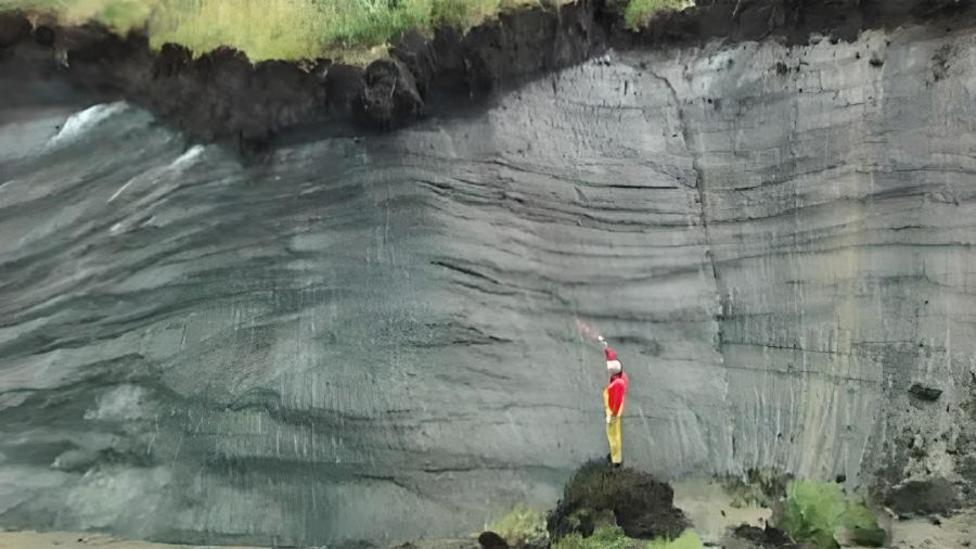
You may think that where it says permafrost on it, there is permafrost in it… That is not precisely how it works. Not all of its range displays permafrost. It may show up continually, intermittently, occasionally, or in patches, depending on the climate and the area.
So, what does this entail?
The only time permafrost is guaranteed is when yearly average temperatures fall below -6 degrees Celsius. It is considered continuous if it extends over 90% of a certain region. Frozen earth may extend several hundred meters underground in some regions. The thickest permafrost soils found to date, at a depth of 1,500 meters, may be found under the swamp taigas in Olenyok River in Siberia (70° northern latitude). Most of these very deep frost soils were deposited throughout the ice ages.
The distribution of permafrost is patchy in regions where only 50-90% of the surface is still covered and where air temperatures do not exceed -3° to -4° Celsius. They are often extinct glacial forms. They just barely survive in the current environment, slightly below zero, and are hence very sensitive to temperature changes. The insulation provided by a plant’s cover is often what prevents them from melting.
It is important to note that even permafrost that covers just a small percentage of the land or occurs in isolated areas is a relic of the previous glacial epoch. They have survived to the present day only in remote locations, behind the shelter of a plant or a blanket of snow, and even there, they are obviously deteriorating.
Where does permafrost exist?
From the Arctic to the South American Andes
Approximately 9 million square miles (22.8 million sq km), or about the size of North America, is still covered by permafrost. Just 3% of Earth’s surface is covered by ice and snow all year round.
Since permafrost can only exist in very cold climates, it is always found in the coldest regions. These include the high mountains and their periglacial altitude zone and the regions near the poles that aren’t permanently covered in ice and snow. Soils that often or permanently freeze over are a hallmark of the periglacial altitudinal zone. The Alps also include this elevation range. Continual permafrost has a minimum depth of 3,000 to 3,500 meters, discontinuous permafrost of 2,500 meters, and occasional permafrost of 2,000 meters.
Small-scale variations in high mountains are more noticeable because of the varying solar orientations of the slopes. The lack of permafrost in the area is due to the high insolation levels up there. They don’t happen until much higher altitudes in wind-protected places, since a consistent snow cover keeps the ground warm throughout the winter.
Where exactly is permafrost soil located?
After all, they include over half of the territory of the former Soviet Union, in addition to 80% of Alaska and 60% of Canada. As a result of the continental climate, permafrost in Siberia persists far into the boreal coniferous forest zone.
Between the northernmost point of Greenland (at 84°N) and the Himalayas (at 26°N), you will find permafrost. The thaw layer becomes thinner and the frozen ground thicker as one approaches the North Pole. Only high mountains, ice-free regions of Antarctica, and subantarctic islands in the southern hemisphere have permafrost.
Frozen ground, though, isn’t limited to continents. It has also been discovered by scientists on the bottom of the ocean. They found permafrost that had developed at the continental boundaries during the ice ages. It was during these chilly epochs that permafrost formed, when the water level dropped below the continental edges. Arctic shallow waterways like Siberia’s Laptev Sea were also found to have permafrost by scientists. Permafrost on the bottom is still believed to have a thickness of 450 meters in the Beaufort Sea off the coast of Canada.
Spread of the permafrost
Northern hemisphere permafrost
More than 50 years have passed since scientists first began mapping permafrost. The International Permafrost Association (IPA) identified the need for a standardized map of permafrost distribution and features throughout the Northern Hemisphere in 1990.
The IPA map displays the location of submerged and relict permafrost as well as ground ice on continents, mountains, and plateaus. North American, Greenlandic, and Arctic island ice sheets and glaciers are shown as well. Anyone interested in studying climate change, conserving resources, protecting the environment, or utilizing the map in the classroom will find it useful.
Solifluction and the dynamics of the periglacial zone
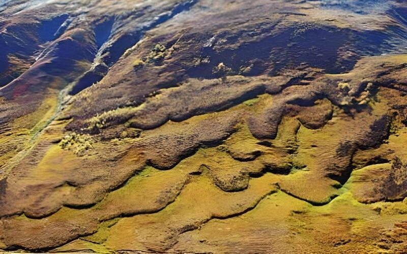
Even the permafrost soil is not entirely frozen due to the continual back and forth. As a result, there is a lot going on at the surface. As the ground thaws, the underlying sediments begin to mix or the whole earth mass begins to shift. The processes become more noticeable as the frequency of frost changes increases. The result is the emergence of distinctive forms and structures, both underneath and on the surface. These forms are helping scientists learn more about the “invisible” permafrost. Periglacial (peri = close, glacis = ice) processes are another name for the forces at work under permafrost.
Soil erosion via the so-called solifluction is nothing to scoff at, even if it is not as dramatic as, say, a landslide. It is possible for soil movement to completely flatten hills.
Even at relatively shallow slopes, the thawed, wet soil mush on top of the still-frozen subsoil begins to slide and travels more or less swiftly downhill toward the slope’s base. Debris cover occurs in bare spots where plants can’t grow. Plants act as a brake on soil movement, leading to the formation of solifluction lobes, which seem like tongues sticking out of the ground.
Pingos, palsas and polygons
Ground ice and cryoturbation
A bottom like that has it rough in the periglacial zones. There is no way for soil to develop there.
The soil’s disarray is mostly due to the presence of water or ice. Because when water freezes, its volume rises by around 10%, that’s a rather significant increase. When the earth freezes in the winter, the surface and the permafrost both expand, leading to stress. To distribute the weight evenly, rocks and sediments are shuffled in every direction. The deformation of soil strata results in distinctive surface features. These “bagging” of the ground during cycles of thawing and freezing, which is known as cryoturbation, are examples of such mixing processes.
Soil with a frost pattern is a surface type that is rather common. From a distance, it seems like dried, cracked dirt. At first, fissures appear in the ground, either as a result of severe freezing or the drying out of the thawing layer throughout the summer. In the winter, the water in the cracks freezes and expands the crack more. Cracked soil is subjected to increased pressure, and cryoturbation brings bigger stones to the top, effectively sorting them. Rolling to the perimeter at the surface of the generally upward-sloping soil polygons. Thus, the frost crack nets become organized receptacles for coarse debris, with the fine soil remaining between.
But ice does not always disperse uniformly via the soil’s tiny pores. Solids are more likely to develop in the correct compact shapes in areas where water may concentrate.
It is well accepted that ice wedges have a significant role in the development of frost-pattern soils. They may “bite” their way into the top section of the frozen soil and grow to be miniature giants over the course of several freeze-thaw cycles. In places where permafrost was present throughout the ice ages, you may still see fossil ice wedges today. The sand, gravel, and loess that filled in the crevices left by the melting ice have kept the shapes visible to this day.
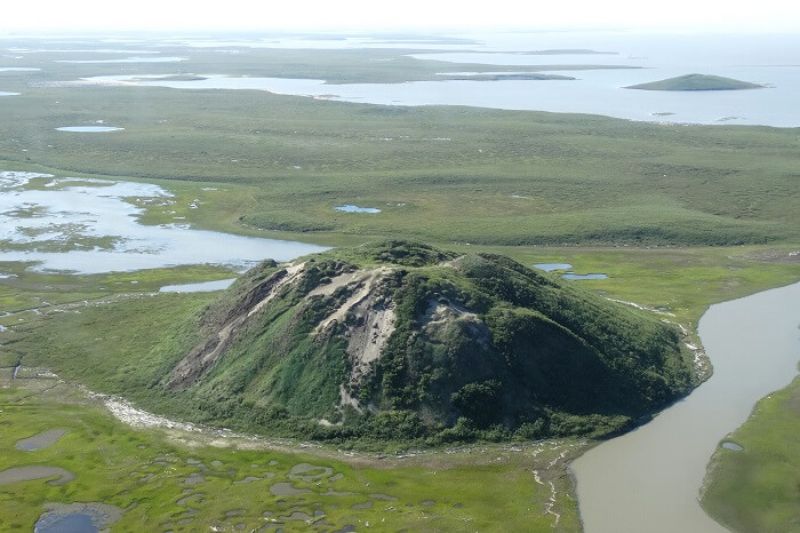
The ice bodies that flip the ground are much more spectacular than the ice wedges. One of the most outstanding examples of this is the so-called pingo. A massive iceberg may be hiding behind a few centimeters of sediment or weathering, with the potential to raise the earth by 10–30 meters and spread out to a width of 300 meters. You may often expect an oval or circular layout. It’s surprising that water can make its way through the permafrost to a single location in such massive quantities.
To put it simply, a palsa is a pingo’s little brother. Because of the peat that tops them, palsas resemble unkempt molehills. They may have a thick ice core that extends for tens of meters.
Thufurs are the tinier of the ground ice humps. They are just around 0.5-1 m in diameter and the same in height. Landscaping is lifted when they freeze because they are loaded with dirt or stones hidden under lawn. When present in great numbers, they transform grasslands into “moguls.”
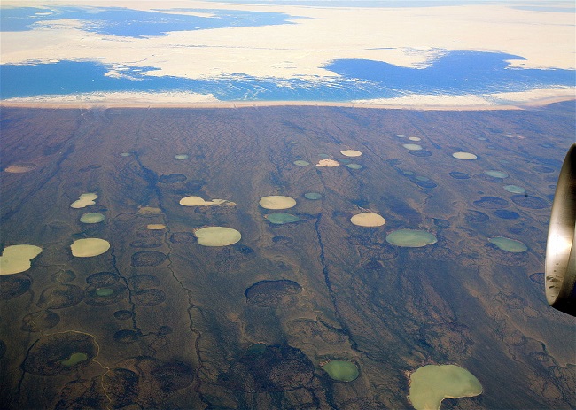
The landscape, particularly in regions with significant ground ice, will alter as permafrost thaws. This is due to the hollow forms filled with meltwater created by the melting ice deposits in the earth. The term “thermokarst” was coined to describe this phenomena because the hollow shapes are reminiscent of those seen in karst topographies. The relevance of temperature—the persistent frost changes—in its development inspired the use of the word “thermo.” Thermokarst has the potential to drastically alter landscapes, transforming forested areas into swampy areas in a matter of minutes.
Glacier blocks
Hidden colossus
Because it consumes the same substance as its environment, it is able to blend in well and may go unnoticed at first. Taking a look at aerial images is often the best way to get a sense of how big a block glacier really is.
Permafrost in the mountains may be detected by the presence of block glaciers. While they share the name, “glaciers,” they neither develop nor behave like real glaciers. The accumulations of angular boulder boulders that have been separated from valley walls due to frost blasting and weathering are easily mistaken for debris-covered glaciers. Inside, ice is what’s keeping the debris piles together.
Boulder glaciers are typically between 10 and 100 meters in height, several hundred meters in length, coated with gritty rubble, and very steep at the front and sides. The debris-ice body slides downslope because the ice has deformed plastically, allowing gravity to perform its work. The motion causes the surface to swell longitudinally and transversely, giving the object a tongue-like appearance.
On average, it makes a few centimeters of progress per year. The Hochebenkar block glacier in the Ötztal Alps is an outlier; it “rushes” downwards at a rate of three to four meters per year.
Other forms, like as fossils and dormant block glaciers, exist alongside these active ones. While permafrost may still be present in an inactive block glacier, the glacier’s movement has ceased because of rising temperatures or a lack of a steep enough slope. The first signs of flora are a telltale sign of a block glacier that has melted and is now dormant.
Alternatively, glaciers made of fossil blocks have lost their ice and are now considered to have collapsed. Vegetation growth makes these ice age fossils easy to see.
Many of today’s dormant block glaciers have been linked by scientists to the human warming of the environment. Because to the greenhouse effect, scientists believe that block glaciers have remained dormant since the middle of the past century.
Natural environment of permafrost
Extreme conditions
Living conditions in the permafrost are harsh for humans, animals, and plants. The dirt is not a very good place to start a life. Hard as a rock ice forms in the winter, while meltwater pools in the thaw layer throughout the summer. Therefore, plants need to be able to withstand both very cold conditions and excessive amounts of water. Sphagnum moss, which thrives in damp environments, is a common inhabitant of marshes.
In such a harsh environment, the ability to adapt is of paramount importance. This means there is less variety among species, and fewer generalists to keep the peace. In central and eastern Siberia, the larch is the most common tree type, whereas the black spruce is the most common in North America and requires little maintenance. There is no way that there could be as many species in one area as there are in a forest of mixed deciduous trees.
Since there are no trees on the tundra, the plants can’t support many people. Plant debris that falls to the ground during these cold spells is unlikely to be broken down by microbes. As a result, there are inadequate resources for plant regeneration. Thus, the regrowth of a destroyed vegetative cover is a relatively gradual process. The loss of plant life may be hastened by human exploitation.
Despite the harsh conditions, some 3.5 million people call the polar regions home. There are around 200,000 individuals in Russia whose ancestors have always lived in this area. They have accepted and adjusted to the harsh environment. The majority of these people are nomad shepherds, traveling constantly throughout the vast Siberian tundra and taiga.
The ecological equilibrium, however, is rapidly shifting. Mineral wealth and the promise of employment have attracted an excessive number of people to the regions. For them, people have constructed roads and houses, and just their weight is enough to cause the permafrost to thaw. The homes would begin to slide if they weren’t stabilized. Building settlement issues, such as cracking and leaning, may be traced back to ground subsidence, which is triggered by an increased depth of the thawing layer.
The permafrost is a treasure trove
The repercussions of exploitation
At first, the permafrost regions drew attention primarily from an engineering perspective. In order to retrieve the riches of the permafrost, it was essential to build roads and pipelines into the region. Those that seek natural gas, crude oil, or precious metals like gold go to the world’s most hostile regions. Siberia is home to over 80% of Russia’s energy and fuel reserves, making the region a huge cash cow for the country because to the export value of natural gas.
However, the permafrost will be negatively impacted by the extraction of these mineral riches. The invasion of the delicate environment has melted the earth. Black asphalt roads, hot oil running through pipelines, and the radiant heat from homes all contribute to the warming of the soil. The layer of melting permafrost increases.
The contamination of large areas of land by oil from ruptured oil pipelines is a serious threat to the environment. Pipelines that can resist the forces induced by frost heaving are notoriously difficult and expensive to construct. Unfortunately, in Russia, the environment is frequently sacrificed to reduce the exorbitant cost of development. Pipelines that are poorly placed often fracture, leak, and even explode, which may lead to devastating forest fires. There is too much heat for the permafrost to survive.
The terrain recovers, if at all, from severe weather conditions very slowly. To the south, where permafrost persists but does not thaw, goes an environment that will never recover. Native communities’ homes are being destroyed due to mining operations. The loss of fertile pastures is especially devastating since it is there that their livelihoods as shepherds are based.


