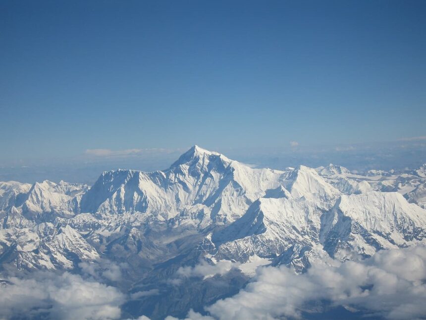
Rising twenty nine thousand and thirty two feet—or eight thousand eight hundred and forty eight meters—into the lower stratosphere along the border of Nepal and Tibet, Mount Everest (known in Nepali as Sagarmatha and in Tibetan as Chomolungma) is the ultimate crucible of high altitude mountaineering. While thousands of climbers have stood on the roof of the world since Sir Edmund Hillary and Tenzing Norgay first reached the summit on May twenty ninth, 1953, the standard South Col route through Nepal remains a two month physiological and psychological gauntlet. Every spring expedition hinges upon surviving five distinct geographical checkpoints between the foot of the glacier and the summit pyramid.
Point 1: The Khumbu Icefall (17,900 to 20,000 Feet)
Immediately after completing weeks of acclimatization treks to Everest Base Camp at seventeen thousand six hundred feet, climbers come face to face with the single most treacherous section of the entire southern route: the Khumbu Icefall. Situated at the head of the Khumbu Valley, this two thousand foot vertical cascade is a frozen river of glacial ice moving downward by three to four feet every single day. As the massive glacier slides over steep bedrock cliffs beneath the Western Cwm, it fractures into a shifting labyrinth of bottomless crevasses and towering blocks of unstable ice called seracs, some standing as tall as ten story office buildings.
Before any commercial climber sets foot on the mountain, an elite team of Nepali Sherpas known as the Icefall Doctors risks their lives to pioneer a route through the labyrinth, anchoring dozens of aluminum ladders tied together with rope across gaping chasms and fixing miles of safety lines. Because daytime sunlight melts the ice bindings and triggers deadly serac collapses—such as the tragic April 2014 avalanche that claimed the lives of sixteen Nepali guides—climbers strap on their headlamps and enter the Icefall in the freezing pitch dark at two or three o’clock in the morning, racing to cross the creaking aluminum ladders with crampons before the morning sun touches the ice.
Point 2: The Western Cwm, the Valley of Silence (20,000 to 22,000 Feet)
Surmounting the top lip of the Khumbu Icefall brings climbers past Camp I into the Western Cwm (pronounced “koom,” from the Welsh word for a bowl shaped mountain valley, named by George Mallory in 1921). Flanked by the sheer vertical walls of Everest’s Southwest Face, Lhotse, and Nuptse, this relatively flat, gently rising glacial basin stretches for nearly three miles up to the base of the Lhotse Face at Camp II (twenty one thousand three hundred feet).
Despite the high altitude, the Western Cwm presents a bizarre thermal paradox that drains climbers’ strength. Because the three towering mountain walls block virtually all wind and act like a giant parabolic solar reflector, on a clear sunny morning the snow surface amplifies solar radiation until temperatures inside the basin soar past thirty five degrees Celsius (ninety five degrees Fahrenheit). Climbers who were shivering in sub zero cold Inside the Icefall two hours earlier suddenly find themselves suffocating in stagnant, thin, superheated air while wearing heavy down boots, earning the Western Cwm its famous nickname, the Valley of Silence.
Point 3: The Lhotse Face (22,000 to 26,000 Feet)
At the head of the Western Cwm rises a sheer, four thousand foot wall of glacial blue ice pitched at angles between forty and fifty five degrees: the Lhotse Face. To reach Camp III, which is perched precariously on a tiny ledge chopped directly into the middle of the ice wall at twenty three thousand five hundred feet, climbers must spend six to eight exhausting hours kicking the front points of their steel crampons into solid ice while sliding their mechanical ascenders (jumars) up a fixed nylon rope.
On the Lhotse Face, high altitude hypoxia begins to take a severe toll on the human body, as every breath contains less than forty percent of the oxygen molecules available at sea level. Above Camp III, before angled traverses across the Yellow Band—a striking layer of ancient marine sedimentary limestone formed on the floor of the Tethys Ocean millions of years ago before tectonic collision pushed it five miles into the sky—and the rocky Geneva Spur, most climbers strap on supplemental bottled oxygen masks for the final push toward the Death Zone.
Point 4: The South Col and the Death Zone (26,000 Feet)
Crossing the Geneva Spur delivers climbers onto the South Col, a broad, wind scoured saddle of black shale and ice connecting Mount Everest and Lhotse at exactly twenty six thousand feet (nearly eight thousand meters). Here sits Camp IV, the final staging ground before the summit push and the threshold of what Swiss doctor Edouard Wyss Dunant famously termed the Death Zone.
Above twenty six thousand feet, atmospheric barometric pressure drops so low that the human body can no longer acclimatize, digest food properly, or repair damaged tissue; even while resting inside a tent, a climber’s body is slowly dying cell by cell. Swept by hurricane force jet stream winds that shred nylon tents, climbers at the South Col rest for only a few hours before departing toward the summit around nine or ten o’clock at night into temperatures plunging below minus thirty degrees Celsius, guided only by a string of glowing headlamps climbing up the Triangular Face toward the Balcony at twenty seven thousand five hundred feet.
Point 5: The Hillary Step and the Summit Ridge (28,700 to 29,032 Feet)
After reaching the South Summit at twenty eight thousand seven hundred feet as dawn breaks across the curvature of the Earth, climbers face the final knife edge cornice ridge leading to the true summit. For over sixty years, this narrow ridge was guarded by the Hillary Step—a nearly vertical forty foot wall of rock and ice at twenty eight thousand eight hundred and forty feet where climbers had to haul themselves up one by one over a ten thousand foot drop into Tibet on the right and a seven thousand foot drop into Nepal on the left. Following the massive 2015 Nepal earthquake, several massive boulders shifted or collapsed, transforming the technical rock climb of the Hillary Step into a steep, snow covered slope, though the bottleneck remains the most dangerous traffic jam on the mountain.
When a climber’s boots finally step onto the dining table sized snow dome of the summit at twenty nine thousand and thirty two feet, standing atop the highest point on Earth surrounded by prayer flags, the celebration is brief. As mountaineers universally remind one another, the summit is only the halfway point: nearly eighty percent of summit day fatalities occur during the exhausting descent down the Hillary Step, the South Col, and the Lhotse Face when adrenaline fades and oxygen tanks run dry.