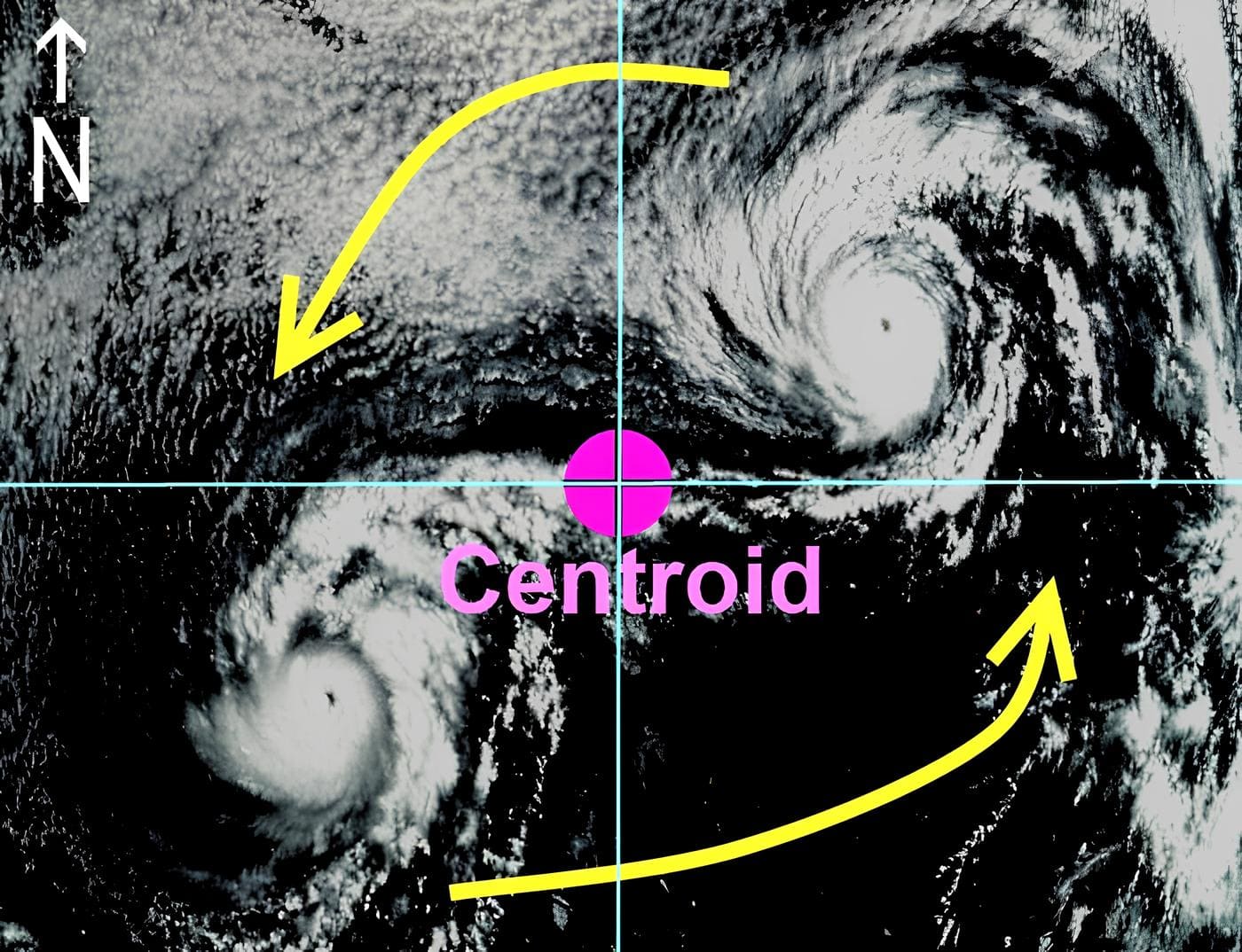
The Fujiwara effect is a condition in which two hydrotropical or atmospheric cyclones (e.g., tropical cyclones) that are not far apart interact with each other due to differences in their vorticity, mass, and relative positions. The Japanese meteorologist Fujiwara Sakiahei first described the Fujiwara effect in a series of hydrographic experiments and studies carried out between 1921 and 1931, primarily to explain the interaction between two tropical cyclones when they form at the same time and are close to one another, hence the name.
It was found that the trajectories of the two approaching water vortices would revolve around each other, with the center of their connection as the center of the circle. A similar phenomenon occurs in atmospheric vortices.
Because the main application of this effect is to explain the special changes when two tropical cyclones are close to each other, some meteorological departments and weather enthusiasts directly call this phenomenon the “binary interaction”. In addition, because Fujiwara Sakiahei was the director of the Central Weather Station of Japan (now the Japan Meteorological Agency) during the Pacific War, and during his tenure, he and Arakawa Hidetoshi were involved in the development of balloon bombs and were convicted of being war criminals by the Allied Forces Command in Japan and were released from their official duties, some organizations, under the factor of political correctness, will also call this phenomenon the “binary typhoon effect”.
The Fujiwhara Effect can have several consequences, including altering the paths of the interacting storms. They can either merge and combine their energies or repel each other and move apart.
Overview of the Tropical Cyclone Effect
The Fujiwara effect between tropical cyclones is not limited to two typhoons, even though some organizations call it the binary typhoon effect. Tropical cyclones usually move in response to changes in sub-tropical high-pressure and low-pressure troughs. As the typhoon itself rotates cyclonically (counterclockwise in the Northern Hemisphere and clockwise in the Southern Hemisphere), the airflow outside the typhoon is also affected by it, resulting in a cyclonic wind field (also known as a driving current field). If a point of mass is located in a cyclonic wind field, it will be driven by the wind field, and its path will be cyclonic. Two typhoons will be cyclonic because of the influence of each other’s wind fields.
The actual large-scale background wind field of the atmosphere is much more complex than the interaction of two typhoons alone. In addition to the release of latent heat from the water and the increase in the Coriolis force of the Earth’s rotation with latitude, the two typhoons may merge, separate, and stretch in addition to circling each other.
Distance is a limiting factor in the Fujiwara effect; two cyclones that are too far apart won’t have the Fujiwara effect. Generally speaking, two typhoons usually approach each other slowly until they are within 1000 kilometers of each other, then they will be influenced by each other and approach each other in a cyclonic spiral trajectory and start to produce the Fujiwara effect.
However, when they reach about 800 kilometers apart, one of two things can happen: they can merge or separate.
Alternatively, the intensity may weaken or dissipate during the process as the typhoon makes landfall, changing the interaction between the two typhoons.
The Fujiwara effect is demonstrated by artificially generating two water vortices in a water tank to show the complexity of the flow as they approach.
Types
There are two main types of the Fujiwhara effect:
Unidirectional Type: When two tropical cyclones have a significant difference in strength, the stronger one will cause the weaker one to rotate counterclockwise (in the northern hemisphere) or clockwise (in the southern hemisphere) around its outer circulation until they separate or merge.
Examples include the interactions between Typhoon Tim and Tropical Storm Vanessa in 1994, Typhoon Sanvu and Severe Tropical Storm Pabuk in 2006, Typhoon Morakot and Typhoon Morakot in 2009, Typhoon Ma-on and Tropical Storm Tokage in 2011, Typhoon Bolaven and Typhoon Tembin in 2012, Severe Tropical Storm Peipah and Tropical Storm Una in 2013, and Severe Tropical Storm Dianmu and Typhoon Lionrock in 2016.
Bidirectional Type: When two tropical cyclones have comparable strengths, they both revolve counterclockwise (in the northern hemisphere) or clockwise (in the southern hemisphere) around a common center, forming a mutual rotation, until other weather systems affect them or one of them weakens.
Examples include the interactions between Typhoon Wayne and Typhoon Viola in 1986, Typhoon Mina and Typhoon Haima in 2007, Severe Tropical Storm Lionrock and Tropical Storm Namtheun in 2010, Severe Tropical Storm Meranti and Tropical Storm Malakas, and Typhoon Rock in 2011.
The Fujiwhara Effect can occur in various parts of the world, but it is most commonly associated with tropical cyclones in the Pacific and Atlantic Oceans.
Key Examples
The Fujiwhara Effect is mainly observed in the northwest Pacific region. This phenomenon is primarily due to the higher frequency of tropical cyclones generated in the northwest Pacific. At times, there can be more than two tropical cyclones simultaneously active in this region, making it susceptible to the Fujiwhara Effect.
Occasional occurrences of the Fujiwhara Effect can be witnessed in the northeast Pacific, North Atlantic, South Indian Ocean, and South Pacific regions. The North Indian Ocean experiences fewer tropical cyclones, and due to its relatively shorter observational history, there are no documented instances of the Fujiwhara Effect to date. The South Atlantic, on the other hand, rarely sees the generation of tropical cyclones, resulting in no known occurrences of the Fujiwhara Effect there.
In the North Atlantic, the year 1995 saw the highest number of Fujiwhara Effect incidents. Hurricane Humberto and Hurricane Iris experienced the Fujiwhara Effect that year, affecting each other’s movement. Subsequently, Tropical Storm Jerry was also influenced by this phenomenon, as Hurricane Iris drew it closer in a convergent manner. In 1994, Tropical Cyclone Pat and Tropical Cyclone Ruth underwent the Fujiwhara Effect, influencing each other’s trajectories and eventually merging into one system. In 2004, Hurricane Lisa absorbed another tropical cyclone, providing another example of this effect.
In the northeast Pacific, occurrences of the Fujiwhara Effect are less frequent. One such example is the case of Tropical Storm Lidia, which was pulled closer and absorbed by Hurricane Max on September 18, 2005.


